Driving in Philadelphia, PA: the expressways, the bridges and tolls
8 min read
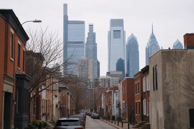
Philadelphia is a city with an unusually good street plan and an unusually bad set of approaches. The Center City grid was laid out in the 17th century on a scheme so rational that you can navigate it without a map after twenty minutes. The expressways that bring you to it were laid out in the 1950s along a river valley with no room to spare, and they have been struggling ever since.
That gap defines the experience. Getting into Philadelphia is the difficult part; being in Philadelphia, once the car is somewhere legal, is one of the most walkable propositions on the East Coast. The historic district, the Center City core and the museum cluster along the parkway sit much closer together than visitors expect.
What follows is the practical side — the expressways, the Delaware bridges, how the cashless tolling works, where to leave a vehicle — and then the parts of the city that reward parking once and going on foot.
The roads into Philadelphia
Four routes carry most of the traffic, and they have very different characters.
I-95, the Delaware Expressway, runs along the river through the length of the city, connecting the airport and the southern suburbs to the northeast and on toward Trenton. It has been the subject of extended reconstruction, so lane patterns and ramp availability change over time and a route you know may not work the way it did.
I-76, the Schuylkill Expressway, comes in from the western suburbs and the Pennsylvania Turnpike and follows the Schuylkill River into the city. It is the one to plan around. Built along a narrow valley with the water on one side and a hillside on the other, it is short of shoulders, tightly curved and carrying far more traffic than it was designed for. One breakdown backs it up for miles.
I-676, the Vine Street Expressway, cuts across the top of Center City in a below-grade trench and links the Schuylkill to the Benjamin Franklin Bridge. I-476, the Blue Route, runs north to south through the western suburbs and is the useful bypass when the Schuylkill is not moving.
The Pennsylvania Turnpike passes east to west well north of the city, with the Northeast Extension running up toward the Poconos.
Tolls and the Delaware bridges
The Pennsylvania Turnpike is entirely cashless. There is nothing to stop for on the main lanes: you pass under a gantry at speed and the charge is either read from a transponder or billed by mail against the license plate, with the plate-billed rate set higher than the transponder rate.
The bridges over the Delaware into New Jersey are tolled in one direction only. You pay heading west into Pennsylvania and cross back to New Jersey without charge, which is worth knowing when a route looks asymmetrical. Choose the crossing by destination: the Benjamin Franklin lands nearest Old City and Center City, the Walt Whitman serves South Philadelphia and the airport, and the Betsy Ross reaches the northeast of the city.
As always with a rental, ask at the counter how tolls are handled before you drive away. The administrative fee added per toll is frequently larger than the toll.
The grid, once you are in it
Center City is laid out on the original plan and it is easy. Numbered streets run north to south and count upward as you move west from the Delaware. Named streets run east to west: Market, Chestnut, Walnut, Spruce and Pine heading south, Arch, Race and Vine heading north. Market divides the address numbering.
Two practical caveats. Most streets are one-way and alternate in direction, so a missed turn usually costs a full lap of the block. And the streets are narrow — genuinely narrow, in places built for carts — with double-parked vehicles a routine part of the traffic pattern rather than an exception.
The narrowness has a knock-on effect worth knowing about. A single delivery truck stopped on a one-way street blocks it completely, and there is no lane to move into, so short delays are frequent and unpredictable. Buses and trolleys share the same space. None of it is dangerous, but it means travel times across Center City are not proportional to distance, and a route that looks like five minutes can take fifteen.
Traffic and timing
The weekday peaks run from roughly seven to nine-thirty in the morning and three-thirty to six-thirty in the afternoon, and they concentrate on the Schuylkill, I-95 and the bridge approaches. Because those corridors have so little spare capacity, the difference between arriving inside and outside a peak here is larger than in cities with more redundant highway networks.
Summer adds a seasonal pattern. Friday afternoons pull heavy volume east toward the Jersey Shore and the Delaware beaches, and Sunday evenings bring it all back. If your travel is flexible, midday on a weekday or early on a weekend morning is markedly easier.
Where to leave the car
Garages are the realistic answer in Center City and Old City. Metered street parking exists and is enforced, and the residential rowhouse neighborhoods are largely covered by permit zones where a visitor’s car will collect a ticket.
The approach that works is to park once for the whole day. The distance from Independence Mall to City Hall to the far end of the Benjamin Franklin Parkway is a long walk but a perfectly reasonable one, and the subway runs beneath Market and Broad if you would rather not do it on foot. Moving the car between the historic district, Center City and the parkway means paying three times for the privilege of sitting in narrow-street traffic in between.
If you are staying in the suburbs, regional rail lines run into the city center frequently enough that leaving the car at a station lot is usually the better trade, and it avoids the Schuylkill entirely.
The stadium complex at the southern end of Broad Street is the one place in the city with parking on an American scale — large surface lots serving all three venues, with a subway station beside them. On an event day it is far easier to reach by train from Center City than by car, since everyone else is aiming for the same set of exits at the same moment.
What is worth stopping for
Organized by where a single parking stop covers several things on foot.
Old City and Independence Mall
This is the densest concentration of founding-era sites in the country, and all of it is walkable. Independence Hall and the Liberty Bell anchor the mall, with the National Constitution Center at its northern end and the Museum of the American Revolution a couple of blocks south. Around them are Christ Church, Franklin Court, Elfreth’s Alley — a lane of houses continuously occupied since the 18th century — and the streets down to the Delaware waterfront.
Park in a garage a few blocks out and cover the whole district in a morning.
Center City
City Hall sits at the crossing of Market and Broad with an observation deck in its tower. Reading Terminal Market occupies a former train shed a short walk east and is the best single place in the city to eat without committing to anywhere in particular. Rittenhouse Square, west along Walnut, is the most pleasant of the original squares and the surrounding blocks are good walking. Broad Street south of City Hall carries a run of concert halls and theaters.
The Benjamin Franklin Parkway
The parkway runs northwest from City Hall to the Philadelphia Museum of Art, whose front steps have their own following, and the collection inside is one of the strongest in the country. Along the way are the Barnes Foundation, the Rodin Museum, the Franklin Institute and the Academy of Natural Sciences, with Logan Square and its fountain in the middle. Behind the art museum, Fairmount Park opens out along the Schuylkill past Boathouse Row and the river trail.
South Philadelphia and the neighborhoods
South of Center City the city becomes rowhouses and corner stores. The Italian Market on Ninth Street is an outdoor market street of long standing, East Passyunk Avenue is a walkable commercial strip, and the stadium complex sits at the bottom of Broad Street with its own parking and a subway stop. West across the Schuylkill, University City holds the Penn and Drexel campuses and the Penn Museum’s archaeological collections.
Using Philadelphia as a base
The position is excellent for day trips. New York is about two hours northeast in decent conditions, Baltimore a similar run south and Washington a little further. Lancaster County and the Pennsylvania Dutch farmland are under two hours west, the Brandywine Valley and its gardens are closer still, and the Jersey Shore and Delaware beaches are an easy morning’s drive east. Gettysburg and the Poconos both fit comfortably inside a day.
The table below lists what is reachable within four hours’ driving, with estimated distances and times, so you can weigh a trip before planning a day around it.
Within four hours' drive of Philadelphia
Places you can reach in a single sitting, with estimated road distance and drive time. Pick any row for the full route, including the towns you would pass.
| Destination | Distance | Drive time |
|---|---|---|
| Levittown, PA | 28 mi | 44 min |
| Vineland, NJ | 40 mi | 48 min |
| Bethlehem, PA | 55 mi | 1 hr 7 min |
| Reading, PA | 56 mi | 1 hr 7 min |
| Toms River, NJ | 59 mi | 1 hr 11 min |
| New Brunswick, NJ | 61 mi | 1 hr 13 min |
| Edison, NJ | 65 mi | 1 hr 18 min |
| Lancaster, PA | 70 mi | 1 hr 25 min |
| Parsippany, NJ | 85 mi | 1 hr 42 min |
| Jersey City, NJ | 91 mi | 1 hr 49 min |