Driving to Phoenix Sky Harbor: access roads and where to park
6 min read
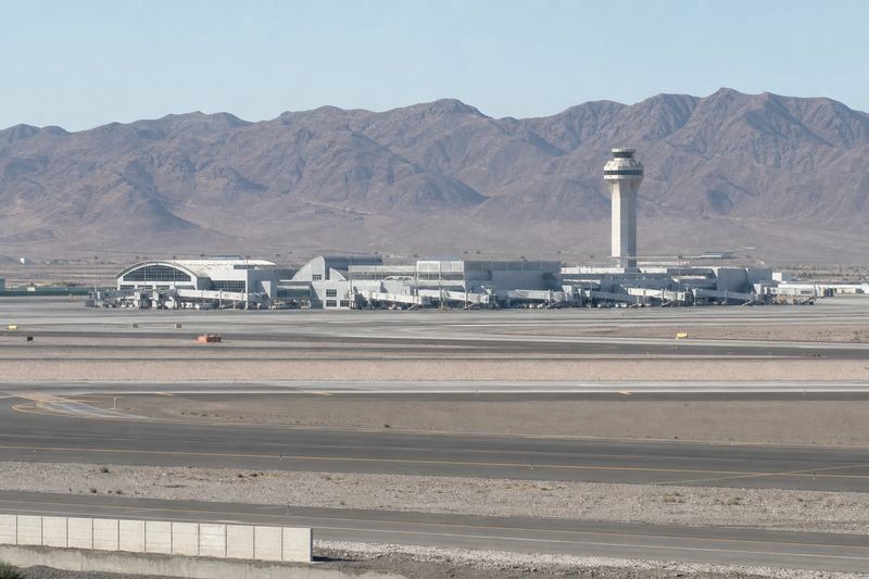
Phoenix Sky Harbor International Airport (PHX) sits about 5 miles by road from downtown Phoenix, AZ — roughly 10 min of driving, or 3.7 miles in a straight line.
Sky Harbor is unusually close to the city it serves, and that single fact shapes everything about driving there. The distance is short. The airport is compact by the standards of its traffic. What can go wrong is the freeway, not the airport.
Getting there by road
The airport occupies a rectangle of land immediately east of downtown Phoenix, hemmed in by freeways on three sides. I-10 runs along the west and south, Loop 202 — the Red Mountain Freeway — along the north, and SR 143, the Hohokam Expressway, along the east. Sky Harbor Boulevard is the spine that runs through the middle of the site and past both terminals.
In practice there are three ways in. From downtown, west Phoenix or Glendale you come off I-10 at the 24th Street exits. From Tempe, Scottsdale, Mesa or anywhere on the east side of the valley you use SR 143 or Loop 202 and enter at the eastern end, which puts you nearer Terminal 4. From the north, 44th Street runs down to meet Sky Harbor Boulevard.
None of that is difficult. The variable is the traffic on the way. I-10 through central Phoenix, and the stack where it meets SR 51 and Loop 202, carry a large share of the valley’s commuting, and both slow badly in the morning and again from mid-afternoon. Because the drive itself is short, a bad twenty minutes on the freeway is enough to double the total. If you have a choice of departure time, the middle of the day is the easy window.
One local factor worth planning for: heat. From late spring into early autumn, an uncovered parking space and a walk across open asphalt are genuinely unpleasant in the middle of the day, and a car left in the open for a week comes back to you very hot indeed. Covered parking is worth more here than it would be in Seattle.
Terminal 3 and Terminal 4
Two terminals are in use, and they are numbered 3 and 4. Nothing is numbered 1 or 2 any more, so the gap is a leftover rather than a sign you have missed something. Terminal 4 is the larger of the two and handles most departures, including international flights.
Sort out which one you need before you are on the airport roads. The signs on the approach send you to a terminal, not to an airline, and Sky Harbor Boulevard is not a road you want to drive twice with a flight to catch.
Curbside at each terminal is split between arrivals and departures, and the departures level is the busy one. If someone is dropping you off, agree the terminal and the level before you leave the house — trying to work it out by phone while circling is how people miss the easy version of this journey.
The Sky Train, and what it connects
The PHX Sky Train is the airport’s automated train. It links Terminal 3 and Terminal 4 with each other, with the economy parking area east of the terminals, with the Rental Car Center, and with a station at 44th Street and Washington.
That last connection is the useful one. It is where the airport meets the Valley Metro light rail, which means the Sky Train is not only an internal shuttle but the last leg of a genuine public transport route into the airport. If you are collecting a rental car or parking in an outer lot, budget for the ride rather than assuming it is instant.
Parking, and choosing between close and cheap
Each terminal has a garage attached to it, and there is cheaper long-stay parking further east, connected by the Sky Train. The decision is the familiar one: pay more and walk less, or pay less and add a train ride to each end of your trip.
For a same-day return or an overnight, the terminal garages usually justify themselves. For anything approaching a week, the economy lots win comfortably and the few extra minutes barely register. There is also a designated waiting area for drivers meeting an arriving passenger, which is a better plan than looping the terminal roads until the phone rings.
The rail alternative
If you are staying in central Phoenix, in Tempe, or anywhere along the light rail line, the train plus Sky Train combination is a real option. It is not fast, but it is indifferent to what I-10 is doing, and it removes the parking decision entirely. For a short trip with hand luggage it is often the better call. For a family with checked bags at six in the morning, it is not.
If you are driving in the city as well as to the airport, the guide to driving in Phoenix covers the freeway numbering, the loops and the parking situation downtown.
Driving in from further out
Sky Harbor is the default airport for most of Arizona, and a lot of its traffic arrives by road from well outside the valley. Tucson is a straight run up I-10 and plenty of people from the south of the state drive it rather than connect. Flagstaff and the high country come down I-17, which loses a lot of elevation on the way and can be a different proposition in winter than the map suggests. Prescott, Payson and Yuma all feed in too, and the seasonal population that spends winters in Arizona adds a long-stay parking pattern you do not see at every airport.
If you are weighing the drive against a flight from somewhere closer, compare it door to door: the drive plus parking plus the airport, against a shorter drive and a connection. The table below gives you the first part of that sum, the distance calculator will handle any route that is not listed, and the other airport guides cover the alternatives.
Driving to PHX from nearby cities
Estimated road distances and drive times to the terminal area. Add your own margin for parking, the shuttle and check-in — these figures cover the drive only.
| From | Distance | Drive time |
|---|---|---|
| Phoenix, AZ (downtown) | 5 mi | 10 min |
| Tempe Junction, AZ | 6 mi | 11 min |
| Tempe, AZ | 8 mi | 16 min |
| Ahwatukee Foothills, AZ | 9 mi | 18 min |
| Scottsdale, AZ | 11 mi | 23 min |
| Alhambra, AZ | 11 mi | 23 min |
| Maryvale, AZ | 14 mi | 29 min |
| Mesa, AZ | 15 mi | 30 min |
| Glendale, AZ | 17 mi | 27 min |
Every figure here is an estimated road distance, worked out the same way as the rest of the site — how the estimate works. Distances in kilometers: downtown Phoenix, AZ is about 8 km away.