Driving in Los Angeles, CA: the freeways, the traffic and parking
8 min read
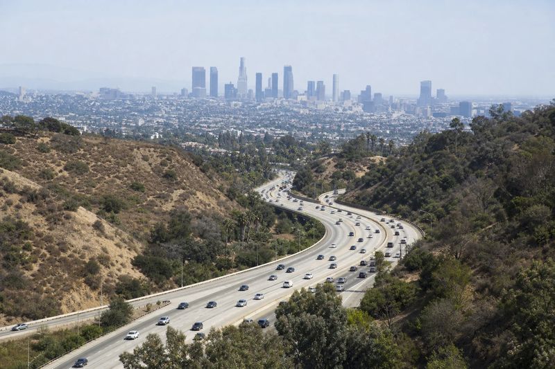
Los Angeles is not a hard city to drive in. It is a hard city to schedule. The freeways are wide, generously signed and mostly straight, the surface streets are laid out on long predictable grids, and the driving itself asks less of you than almost any East Coast city. What it asks instead is patience, and an honest relationship with the clock.
The single adjustment visitors have to make is to stop thinking in miles. Two places twelve miles apart may be twenty minutes away from each other or an hour and ten, depending entirely on when you leave. Locals quote travel times rather than distances for exactly this reason, and they will ask what time you are going before answering how long it takes. The distance calculator gives you the mileage; the clock does the rest.
What follows is the practical side of it — the freeway network and how it is named, where the tolled lanes are, when the traffic actually breaks — and then the parts of the region that justify the drive, organized so that one parking decision buys you a full day on foot.
The roads into Los Angeles
The freeway network is a lattice rather than a hub, which is a consequence of the region having several centers instead of one. There is no single road into town.
From the north, I-5 arrives over the Tehachapi mountains through the Newhall Pass as the Golden State Freeway, and US-101 comes down the coast and then inland through the San Fernando Valley as the Ventura Freeway. From the south, I-5 continues from San Diego as the Santa Ana Freeway and I-405 runs parallel closer to the coast. From the east, I-10 crosses the desert as the San Bernardino Freeway and becomes the Santa Monica Freeway west of downtown.
Two habits will make directions comprehensible. First, freeways here take the definite article: the 5, the 10, the 101, the 405. Second, most of them have names as well as numbers, and traffic reports use both interchangeably. The Harbor Freeway and I-110 are the same road; so are the Hollywood Freeway and the stretch of US-101 north of downtown.
Tolls and ExpressLanes
Los Angeles County has no traditional toll roads. What it has instead are ExpressLanes on sections of the Harbor and San Bernardino freeways — former carpool lanes that solo drivers may buy into, at a price that rises and falls with congestion.
These lanes are transponder-only. They do not bill a license plate and they do not take cash, so a visitor without a transponder should stay in the general lanes and treat the ExpressLanes as carpool lanes. Rental companies sometimes supply a transponder; ask rather than assume.
South of the county line, Orange County does have genuinely tolled routes running inland through the hills. Those are all-electronic as well, either transponder or plate-billed, and if a route suggestion sends you onto one it is worth knowing before the bill arrives.
Reading the traffic
The weekday peaks run roughly from seven to ten in the morning and from three to seven in the evening, and Friday afternoons start earlier and finish later than the rest of the week. The part that surprises people is that both directions are busy. Jobs are spread across the basin, so the reverse commute carries real volume and there is no dependably empty side.
A few corridors have their own rules. The Sepulveda Pass, where I-405 crosses the Santa Monica Mountains, slows at times that have nothing to do with commuting, weekends included. The 101 through the Cahuenga Pass does the same. Coastal routes load up on warm weekends from mid-morning. Midday on a weekday is the calmest general window, and early on a weekend morning is better still.
Two other things belong in any plan here. Navigation apps will happily route you off the freeway and through residential streets to save a few minutes, and in the hillside neighborhoods this has become contentious enough that some streets carry restricted turns during peak hours. The posted sign wins over the app.
The second is event traffic. The stadiums, the arenas and the Hollywood Bowl each release a large crowd onto a small number of roads, and the surrounding area seizes up for an hour on either side of the event whether or not you are attending it.
Where to leave the car
Parking is rarely the problem it is in older cities, because the region was built on the assumption that everyone would arrive by car. Lots, garages and valet stands are the default at almost any destination.
The genuine hazards are the two things posted on signs. Residential permit districts cover large parts of the flatland neighborhoods, and they are enforced. Street cleaning restrictions apply on a specific day and window that changes block to block. The rule is to read the whole sign from top to bottom, including whatever is written in small type at the bottom, because that is usually where the exception lives.
Where a destination sits inside a walkable district — downtown, Old Pasadena, Santa Monica, central Culver City — park once and stay out of the car. Where it does not, accept that you will drive between stops and plan a route that does not double back across the basin.
Two specific cases repay a little planning. Beach parking is in municipal lots along the sand, and on a warm weekend the ones nearest the water fill by mid-morning while the lots a few blocks inland stay open much longer. And valet parking is an ordinary arrangement at restaurants and hotels here rather than a mark of expense, so it is worth carrying some cash for it.
What is worth stopping for
Organized around single parking stops rather than a geographic sweep.
Downtown and Grand Avenue
Downtown has become the densest walkable stretch in the region. Grand Avenue on Bunker Hill carries Walt Disney Concert Hall, The Broad and the Museum of Contemporary Art within a couple of blocks of each other. Walk downhill and you reach Grand Central Market, the Bradbury Building, the old theater district on Broadway and Little Tokyo. Olvera Street and Union Station sit at the northern end, and Union Station is worth a look on its own account.
This is the one part of Los Angeles where a garage and a day on foot works exactly as it would in an older city.
Griffith Park and Hollywood
Griffith Park is one of the largest urban parks in the country and holds the observatory, an open-air amphitheater, the zoo and a network of trails, including the ones that produce the standard view of the Hollywood sign. The observatory road is narrow and its lots are small, so go early or use the shuttle on busy days.
Hollywood itself is a short distance south: the Walk of Fame, the old movie palaces along Hollywood Boulevard with their handprint forecourts, and the Hollywood Bowl in the pass above. Park in a garage rather than circling, and expect the sidewalk crowds to be the main obstacle.
Museum Row and the Miracle Mile
A stretch of Wilshire Boulevard west of downtown holds several major institutions in walking distance of one another — the Los Angeles County Museum of Art, the La Brea Tar Pits with their active excavations, and the automotive museum across the street. Hancock Park and its neighborhoods sit immediately north and are pleasant to walk.
The beaches
Santa Monica and Venice sit next to each other at the western end of I-10, with beach lots along the sand and structures in the town center. From there the boardwalk runs south past Venice Beach to the canals, and the pier anchors the northern end. Further south, Manhattan Beach, Hermosa and Redondo are quieter, and Long Beach at the bottom of I-710 has the harbor and the aquarium.
North of Santa Monica, Pacific Coast Highway runs the length of Malibu with pullouts, state beaches and canyon roads climbing into the mountains. It is slow and it is worth it.
Pasadena and the eastern side
Pasadena is a genuine second downtown with a walkable core, and the San Gabriel Valley behind it holds the Huntington’s library and gardens, the Rose Bowl in its arroyo, and the foothill towns below the mountains. The Angeles Crest Highway climbs from there into the San Gabriels and gets you above the basin within an hour.
If you are flying in, the LAX guide covers drive times from around the region; the airport sits close to the coast and its access roads are best avoided at the peaks.
Using Los Angeles as a base
The geography here is unusually generous for day trips. San Diego is a couple of hours south, Santa Barbara a similar run north along the coast, and Palm Springs and the desert about the same to the east. Big Bear and the mountain resorts are reachable in a morning. Joshua Tree is a comfortable day out, and the southern Sierra sits at the outer edge of a long one.
The table below lists what is reachable within four hours’ driving, with estimated distances and times, so you can judge a trip before you plan a day around it.
Within four hours' drive of Los Angeles
Places you can reach in a single sitting, with estimated road distance and drive time. Pick any row for the full route, including the towns you would pass.
| Destination | Distance | Drive time |
|---|---|---|
| Fullerton, CA | 27 mi | 43 min |
| Glendora, CA | 27 mi | 43 min |
| Westminster, CA | 30 mi | 47 min |
| Diamond Bar, CA | 30 mi | 48 min |
| Pomona, CA | 34 mi | 54 min |
| Santa Ana, CA | 37 mi | 58 min |
| Costa Mesa, CA | 41 mi | 50 min |
| Upland, CA | 42 mi | 50 min |
| Thousand Oaks, CA | 43 mi | 51 min |
| Irvine, CA | 44 mi | 52 min |