Driving in Houston, TX: the freeways, the tolls and the feeders
8 min read
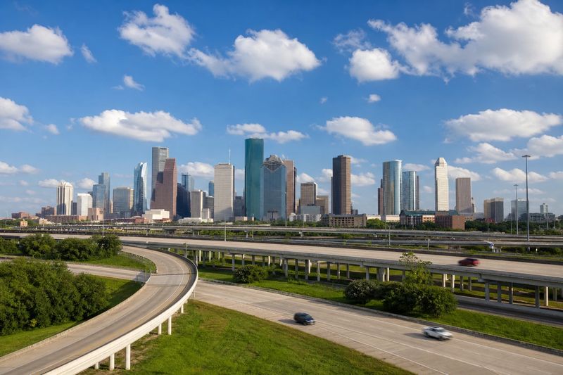
Houston is one of the easier large American cities to drive in, provided you accept its terms. The roads are wide, the speeds are high, the signage is generous and there is almost always a parking space at the other end. What it demands in exchange is a tolerance for distance, because the metropolitan area is vast and there is no single center that everything orbits.
It also runs on two pieces of local road engineering that visitors have to learn quickly: the feeder road system, which changes how you get on and off a freeway, and the U-turn lanes under the overpasses, which change how much a wrong turn costs. Neither is complicated. Both are unfamiliar if you have not driven in Texas before.
What follows covers the freeway and loop structure, how the electronic tolling works, the flooding risk that shapes driving here more than traffic does, and then the districts where one parking stop buys a day on foot.
The roads into Houston
The framework is a set of concentric loops crossed by radial freeways, and once you have the loops straight the rest falls into place.
I-610, universally called the Loop, is the inner ring around the central city. Beltway 8, which carries the Sam Houston Tollway on its main lanes, is the middle ring several miles out. The Grand Parkway is the outer ring, well beyond the developed area in places and still being extended.
The radials do the long-distance work. I-45 runs northwest to Dallas as the North Freeway and southeast to Galveston as the Gulf Freeway. I-10 crosses east to west as the East Freeway and the Katy Freeway, the latter being one of the widest highways anywhere. I-69 combines with US-59 to run southwest as the Southwest Freeway and northeast as the Eastex Freeway. US-290 heads northwest, and State Highway 288 runs south toward the coast.
As in much of Texas, the names matter as much as the numbers. Traffic reports say Katy Freeway and Gulf Freeway rather than I-10 east and I-45 south, and directions from a local will use the names.
One structural point is worth flagging early. Because the metro area has no single dominant center, the loops carry as much long-distance traffic as the radials do, and a trip between two suburbs will often use them rather than passing through the city at all. The practical consequence is that the shortest-looking line on a map — straight through the middle — is frequently the slowest option available, and going the long way around a ring is often faster.
The interchanges are the other thing to prepare for. Where two freeways meet here they do so across several elevated levels, with exits taken from the left as readily as the right, and the lane you need is often signed a mile or more in advance. Getting into it early costs nothing; discovering it late means the next exit.
Tolls and the tolled lanes
The rings and several of the radial corridors carry tolls, and collection is electronic. There is nothing to stop for: traffic passes under a gantry at speed and the charge is read from a tag on the windshield or billed to the registered plate. Several routes have removed cash handling entirely.
For a visitor the practical question is the rental car. Companies handle electronic tolls in their own ways, and the administrative fee attached to each individual toll is regularly larger than the toll. Ask at the counter whether a tag is fitted and how billing works before you leave.
There are also managed lanes on some corridors that operate as high-occupancy lanes at the peaks and open to solo drivers for a charge at other times. The signs state the current rule, and it changes through the day, so read them rather than assuming yesterday’s arrangement holds.
Feeder roads and turnarounds
Every Houston freeway has a two-way surface street running alongside it on each side. These are the feeder roads, and they are where the businesses are. Exiting the freeway generally drops you onto a feeder, and you travel along it to whatever you were aiming for. When the main lanes stop moving, the feeder is a legitimate alternative for a mile or two.
Connecting the two feeders at most overpasses is a dedicated U-turn lane, the Texas turnaround, which passes under or over the freeway without entering the intersection. The consequence is that missing your destination barely matters here. Carry on to the next overpass, turn, and come back along the other side.
Flooding, heat and the weather that matters
Houston is flat and low, laid out across a network of bayous, and it gets intense rainfall. Water collects in underpasses and dips in the roadway faster than drainage can clear it, and the depth is genuinely impossible to judge from the driver’s seat.
The standing advice is the correct advice: do not drive into water. A relatively shallow flow is enough to move a car, and a flooded underpass can be far deeper than the surface suggests. Turn around and find another route. During heavy rain, check conditions before setting out rather than discovering them on the road.
Heat is the other constant. From late spring into fall the afternoons are hot and humid enough to matter for tire pressure, cooling systems and anyone waiting outside a car. Park in shade where you can find it, carry water, and plan walking for the morning or the evening rather than the middle of the day.
Where to leave the car
Parking is one of the things Houston does well. Almost every destination has a lot or a garage, and outside downtown the rates are modest by big-city standards.
Downtown has garages, surface lots and metered street parking, plus one genuine advantage: an extensive underground pedestrian tunnel network links a large number of buildings in the core. One garage in the right place puts a much larger area within walking reach, in air conditioning, which in August is not a small consideration.
Elsewhere, the districts worth visiting mostly have their own parking. The pattern that works best is the same as anywhere: pick a district, park once, and walk it rather than driving between individual stops.
Events are the exception to the general ease. The downtown ballpark and arena and the stadium complex further out each empty a large crowd onto a limited set of exits, and the garages around them take a while to clear afterward. If a game is part of the day, arriving early costs less time than leaving early saves.
What is worth stopping for
Organized by where a single parking stop covers several things on foot.
The Museum District and Hermann Park
This is the strongest park-once area in the city. Several major institutions sit within walking distance of one another, including the Museum of Fine Arts, the Houston Museum of Natural Science and the Children’s Museum, with the Contemporary Arts Museum among them. Hermann Park adjoins them with the zoo, a Japanese garden and an outdoor theater, and Rice University’s tree-lined campus is on the far side.
A short distance northwest, in Montrose, the Menil Collection sits in a residential setting with its own grounds and satellite buildings, and the Rothko Chapel is beside it.
Downtown
Downtown works better on foot than its reputation suggests. Discovery Green is a real park in the middle of it, the theater district clusters several venues within a few blocks, and the baseball and basketball arenas are both walkable from the core. The tunnel network connects a good deal of it below ground.
Buffalo Bayou and the Heights
Buffalo Bayou Park runs west from downtown along the water with trails on both banks, and it is the best place in the city to walk or cycle any distance. At dusk in the warmer months, a large bat colony emerges from under the Waugh Drive bridge, which is a genuinely odd and genuinely free thing to watch.
North of there, the Heights has a walkable main street and a long stretch of bungalow neighborhoods, and it is one of the few parts of Houston laid out before the car.
The space center and the coast
South down I-45, the Johnson Space Center’s visitor complex sits between the city and the coast and has its own parking. Keep going and you reach Galveston, with a seawall, a historic downtown and the Gulf. It is close enough to be an easy day out, and the drive is straightforward apart from summer weekend traffic in both directions.
Using Houston as a base
Houston sits within reach of a lot. Galveston and the upper Texas coast are the obvious short runs. Austin and San Antonio are both comfortable half-day drives west, the Hill Country begins just beyond them, and Louisiana starts a couple of hours east. Dallas is a long day up I-45. The city driving guides cover several of these from the other direction.
The table below lists what is reachable within four hours’ driving, with estimated distances and times, so you can weigh a day trip before planning around it.
Within four hours' drive of Houston
Places you can reach in a single sitting, with estimated road distance and drive time. Pick any row for the full route, including the towns you would pass.
| Destination | Distance | Drive time |
|---|---|---|
| Conroe, TX | 47 mi | 56 min |
| Galveston, TX | 54 mi | 1 hr 5 min |
| Beaumont, TX | 91 mi | 1 hr 50 min |
| College Station, TX | 97 mi | 1 hr 56 min |
| Bryan, TX | 101 mi | 2 hr 1 min |
| Lake Charles, LA | 154 mi | 2 hr 34 min |
| Pflugerville, TX | 166 mi | 2 hr 46 min |
| Round Rock, TX | 171 mi | 2 hr 51 min |
| Temple, TX | 174 mi | 2 hr 54 min |
| Georgetown, TX | 175 mi | 2 hr 55 min |